
survey accessories

Sunway ATS 120R Total Station
Sunway ATS-120R Total Station is the most economical model, measures without prism up to 600m, configured with advanced dual axis compensator for automatic error elimination and automatic compensation of accuracy, diversified data transfer options such as card SD, USB pen drive, data cable interface. This high precision total station is widely used in surveying, topography and cartography, engineering construction, is popular in the market of measuring instruments for its high precision, good quality, competitive price. 2″ Accuracy Construction and Survey Application Software On Board Dual Side Display Control Panel. Reflectorless operation upto 600m. IP55 – Strong Environmental Specification against Tough Sites Integrated Bluetooth® technology Up to 16 hours of battery life Key buttons are illuminated to minimze mistakes. USB Pen Drive & SD Memory Card Support Internal memory has 20,000 points to record. Key Features Sunway ATS-120R Series Total Station Sunway ATS-120R series Total Station is used in engineering, produce by Suzhou Sunway Photoelectric Technology Co.Ltd., a subsidiary of a Hi-Target Surveying Instrument Co.Ltd.It have no prism measurement function, absolute encoder angle measurement technology, angle measurement accuracy 2 seconds, no prism measurement accuracy 3mm+ 2ppm and a breakthrough in the use of the STM32 architecture. Sunway ATS-120R series Total Station configures a variety of communication interfaces and smart calibration software implements the diversity of data transmission selection and real-time detection function. Powerful and Fast EDM CapabillitySunway ATS-120R series Total Station’s no prism measurement range up to 1000 meters. No prism measurement accuracy 3mm+2ppm. Accurate measurement 0.8S, Track measurement 0.3S. STM32 ArchitectureThe STM32 MCU based on ARM CortexTM-M processor enables the total station has extra high processing speed and low-power consumption. Intelligent Calibration SoftwareAccessible for real-time diagnosis to ensure trouble-free operation. The software can determine 90 percent of the Problem. Absolute Encoder Angle Measurement1023 pairs of absolutely coded disc. All Sunway ATS-120R Series angle measurement accuracy is two seconds. Starting without initialization.The data will save automatically when the power failure. Stable Dual-axis CompensationCompensation range 3′. Operation can be visualized and High accuracy of angle measurement. Rich Communication and TransmissionWith RS232C, SD, USB and MiniUSB communication interface. Using Bluetooth for data transmission, make data transmission more convenient. Reliable Large Volume MemoryInternal memory has 20,000 points to record.USB memory can be used up to 8GB.
...more
NTS 362R6 South Total Station
South Total Station NTS-362R6 is functioned by reflector-less distance measurement, range up to 500m which is applicable for long distance measurement with high accuracy on various kinds of materials or colors such as wall, wire pole, wire, cliff, hill, earth, timber pile, etc. For those targets which are not easy or even impossible to reach, reflector-less distance measurement can complete the measurement task easily. 2″ Accuracy 2″ Accuracy Fast distance measurement of 0.5s(Tracking Mode). 17000 Points internal memory Absolute Encoding Disk Dual Axis Compensation SD card Function and USB interface 500m Reflectorless Distance Measurement IP65 water proof rugged and operator friendly. Various surveying programs inbuilt Standard usage temperature range-20°to +50°C. SOUTH Total Station NTS-362R6 is embedded with various outstanding surveying programs, coupled with functions of data storing and parameter setting, which can be widely applied in various kinds of professional and construction survey. Absolute Encoding DiskWith absolute encoding disk, you can start your work directly as the instrument is powered on. Azimuth angle will be saved even if the power is off incidentally in the job. Six-line large LCDConvenient Management on Internal Memory. Huge capacity of internal memory enables you to easily complement file system management, including adding, deleting, modifying and transferring data. SD card Function and USB interfaceSD card provides huge memory, fast speed of data transferring, incredibly flexibility and reliable safety. Saving various data of job into the SD card, you can easily read it just by inserting it into the SD port of your laptop. USB interface is the international mainstream for PC communication, with it your job must be much easier. Reflectorless Distance MeasurementSouth Total station NTS-360R6 series is functioned by reflector-less distance measurement, range up to 500m which is applicable for long distance measurement with high accuracy on various kinds of materials or colors such as wall, wire pole, wire, cliff, hill, earth, timber pile, etc. For those targets which are not easy or even impossible to reach, reflector-less distance measurement can complete the measurement task easily. Various Surveying ProgramsBesides of ordinary surveying programs, such series of total station also has special surveying programs, such as remote height measurement, offset measurement, remote distance measurement, stake out, resection, area calculation, road design and stake-out, etc., which are sufficient to meet the needs of professional measurement and surveying measurement.
...more
Measuring Tools
We are offering measuring tools the sokkia total station set-05n provides an accurate, low cost measuring solution featuring: specification : 2" angle accuracy provides 1/16th of an inch accuracy at 1,000ft. Dual keyboards with and expanded numeric keypad for faster data input. Accurately measure up to 2,000m with a single prism. Internal data storage for up to 24,000 points. Single axis compensator with â±3? compensating range. Adopted absolute encoder, which doesnâ��t require 0 set. Thanks to this encoder, it can realize stable measurement with less reading error. Ip54 environmental protection rating. On-board data collection, stakeout /survey, road calculation, and many more functions.
...more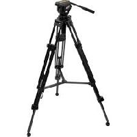
Professional Tripod
The Leica TRI 100 is fitted with a high quality multi directional head which can be rotated through 360 degrees and pivoted through 180 degrees. Flip lever leg locks make opening, positioning and closing fast and easy. The tension of the locking mechanism is user-adjustable, and all parts can be easily serviced or replaced. Built-in, carefully hand-set bubble spirit levels helps make sure your horizons really are horizontal Sturdy all-metal construction. Geared center column allows safe, precise height adjustment even under heavy loads.
...more
Prexiso Electronic Theodolite TO-2
The Prexiso T.O.2 digital electronic theodolite is designed for enhanced reliability in construction applications. Its advanced features let contractors work faster and longer, improving productivity and increasing profitability. With vertical compensation and 2″ accuracy the Prexiso T.O. 2 provides you with the precision required for your most demanding jobs for an affordable price without adding complexity. Various display modes, hold and set zero for horizontal angle, a variation of measurement units, simple distance measurement via stadia lines combined with six function keys guarantee easy use. The visible laser plummet enables you to set up over a point faster and easier than ever. The Prexiso TO 2 Digital Theodolite is the tool of your choice when it comes to checking angles, alignments, grade work and short range levelling. Prexiso T.O.2 having 2″ accuracy Telescope Magnification: 30x Minimum focusing distance: 1.35m Dual side display Laser Plummet for easy setup Horizontal & Vertical Angle Measurement Enhanced Reliability 2’’ horizontal and vertical readout Precision dual LCD panels with large, easy-to-read numbers Vertical angle measuring provides three different options plus percentage of grade Easy-to-read & easy-to-use Auto Power Off option Laser plummet Zero resetting Removable tribrach for multiple set-ups Audible right-angle notification Once the (0) horizontal angle is determined, the Prexiso T.O.2 emits an audible tone for each of the right angle directions Beeping stops when the units comes within +/– 1° Rugged IP54 protection Water resistant, sealed construction One year warranty Prexiso Digital Theodolite TO 2 Technical Specifications:
...more
Mini Prism
Benefit from the quality, precision and reliability of Leica Geosystems Original Accessories – perfectly suited for Leica Geosystems measuring equipment. You’ll recognize Original Leica Geosystems Accessories by the security label with an unique code and colour-shifting logo, found on either the packaging or additional leaflet.
...more
Leica TRI 200 Tripod
The Leica TRI 200 Tripod is a surveyor style tripod that is more stable and durable. This package is for professionals that frequently measure on uneven grade, in rugged environments and in the elements. The Leica TRI 200 pack includes a soft bag with a carry strap for easy mobility in the field. Offers the ability to setup on rugged, uneven terrain Works with all Leica DISTO and LINO products Includes soft carry bag for quick transport DISTO requires use of TA360 & FTA360 or FTA360-S tripod adapter with the TRI 200 The Leica TRI200 Tripod offers a 1/4-inch – 20-millimeter male threaded adapter for mounting Leica DISTO*, LINO, and Camera devices. With a similar setup to construction tripods, the Leica TRI 200 offers a sturdy platform for accurate measuring or photography. The TRI200 also features rubber feet to protect the working surface. Leica TRI200 tripod includes soft case for easy transport. *For use with Leica DISTO must also purchase TA360 Adapter, FTA360-S Adapter for Leica S910, & FTA360 Adapter for Leica D810 & D510.* PRODUCT SPECIFICATION Aluminum tripod Bubble level ¼” fixing screw on head Flip levers for easy adjustment Weight: 1.8 kg Working height from 0.75m to 1.15m
...more
leica runner
These Leica Optical levels are unshakeable. With a level from Leica you can just keep on working. The Leica RUNNER 24 levels are ideal construction levels for site foremen ,engineers, architects, landscape gardeners, carpenters, construction companies and many more. A solid metal housing provides a robust mounting for the high quality Leica optics and compensator. This ensures the Leica Runner is truly SITE TOUGH working in the Harshest environments time and time again. A two year warranty is Leicas commitment to this quality.
...more
Leica GZM 26 Target Plate
Leica GZM 26 – A4 Size Target Plate An important condition for achieving a precise measurement with a laser distance meter is a perfect reflecting target. Leica Geosystems offers target plates which can be used to measure long distances or which can be fixed at corners, edges or over floor marks. Other types of target plates are used to locate the line or rotation lasers beams. For measurement on non-reflecting surfaces Usable on both sides – grey for shorter distances and brown for longer distances Size: 210 x 297mm Product Description Leica GZM 26 – A4 Size Target Plate An important condition for achieving a precise measurement with a laser distance meter is a perfect reflecting target. Leica Geosystems offers target plates which can be used to measure long distances or which can be fixed at corners, edges or over floor marks. Other types of target plates are used to locate the line or rotation lasers beams. For measurement on non-reflecting surfaces Usable on both sides – grey for shorter distances and brown for longer distances Size: 210 x 297mm
...more
Leica GLB30 Laser Glasses
When working outside, it might be difficult to see the laser line or dot. Special glasses guarantee an optimal visibility of the laser lines and dots in bright conditions and over longer distances. For outside applications with a laser, Leica Geosystems recommends one of its high quality GLB30 laser glasses. For improved visibility of red laser dots or lines in bright rooms and outdoors up to 15m With a weight of 18g, it is the world’s lightest laser visibility glasses 3 in 1: the first set of glasses in the world that comes with lenses for laser visibility, safety and sun protection All 3 lenses are scratch resistant The safety glasses and sun glasses are non-fogging A lacquer system features nanotechnology The soft plastic ensures maximum comfort and excellent non-slip properties Including micro fibre bag which can also be used for cleaning
...more
Leica FTA360 Tripod Adapter
Product Description Leica FTA360 Tripod Adapter – for precise targeting For precise measurement or levelling task it is important to perfectly position the laser device. Therefore Leica Geosystems offers different types of adapters & clamps for your application needs. Measuring over long distances requires a stable set-up of the laser distance meter. It is often difficult to fine adjust the laser dot at the target point by holding the device to a stable reference or if mounted on a tripod by moving its head. Leica Geosystems have addressed this problem by introducing the new FTA360 tripod adapter with fine-adjustment for easy and precise targeting. This new adapter fits with Leica tripods TRI70, TRI100 & TRI200. It supports the new Leica DISTO D810 touch which has a special reference setting for this adapter as well as the Leica DISTO D510, D5, D8 & D810 Touch. Together with the new FTA360 adapter the Leica DISTO™ products become highly precise measuring stations. Stable adapter with fine adjustment for convenient and accurate aiming Minimized measuring deviation for indirect measurement Fits perfectly on Leica TRI70, TRI100 & TRI200 tripod
...more
Leica Builder-106 Digital Theodolite
Leica Builder-106 Digital Theodolite Alignment work made easy – Leica Geosystems offers Industrial & Construction Theodolites with outstanding performance and maximum flexibility. Leica Builder 100 Series Construction Theodolites The era of purely mechanical or optical instruments is over. This is the era where digital instruments are needed to remain competitive. The easy-to-use Leica Builder-106 leads the way and sets an industry’s benchmark. For anybody working on or around a site with the need of a simple, intuitive, yet innovative, long-lasting and powerful measuring tool. With the Leica Builder-106, Leica Geosystems has designed a perfectly tailored tool for every construction job. Regardless of your profession, the Builder will amazingly accelerate your work flow. From simple tasks to professional all-day use, the Builder Series offers a scalable product family that exactly meets your needs. Leica Builder 100 – if you need to trust angles and alignmentsWith a laser plummet for simple and fast setup over control line, dual axis compensation for accurate plumbing, endless drives eliminating steps, audible notice for 90° turns, graphical leveling aid for fast and convenient setup and IP55 rating, the Leica Builder 100 is an outstanding theodolite. Leica Builder-106 Set Digital Survey Theodolite Technical Specs:
...more
laser measuring equipment
Laser Distance Measurer, Laser Distance Measurer Reviews, Laser Distance Measuring Device, Laser Distance Measuring Tools, Laser Distance Meter Review, Laser Distance Measuring Instrument India, Laser Distance Tape, Laser Distance Finder, Digital Distance Measurer, Digital Distance Measurement Meter, Electronic Distance Meters.
...more
Garmin eTrex 10 Handheld GPS
Garmin eTrex 10 Handheld GPS retains the core functionality, rugged construction, affordability and long battery life that made eTrex the most dependable GPS device available. We improved the user interface and added a worldwide basemap, paperless geocaching and support for spine-mounting accessories. Worldwide basemap 2.2″ monochrome display, easy to read in any light GPS and GLONASS satellites for faster positioning Paperless geocaching 1000 Waypoints/Favourites/Locations 50 Routes Track Log: 10,000 points, 100 saved tracks 25-hour battery life with 2 AA batteries Product Description Key Features of Garmin eTrex 10 Handheld GPS Rugged Handheld GPS with Enhanced Capabilities Worldwide basemap 2.2″ monochrome display, easy to read in any light GPS and GLONASS satellites for faster positioning Paperless geocaching 25-hour battery life with 2 AA batteries Garmin eTrex 10 retains the core functionality, rugged construction, affordability and long battery life that made eTrex the most dependable GPS device available. We improved the user interface and added a worldwide basemap, paperless geocaching and support for spine-mounting accessories. See the WayGarmin eTrex 10 GPS has an enhanced 2.2″ monochrome display that’s easy to read in any lighting situation. Both durable and water resistant, eTrex 10 is built to withstand the elements. Its easy-to-use interface means you’ll spend more time enjoying the outdoors and less time searching for information. eTrex 10 features the legendary toughness that’s built to withstand the elements. Dust, dirt, humidity, water — none are a match for this navigator. Find FuneTrex 10 supports geocaching GPX files for transferring geocaches. Visit OpenCaching to start your geocaching adventure. By going paperless, you’re not only helping the environment but also improving efficiency. eTrex 10 stores and displays key information, including location, terrain, difficulty, hints and descriptions, which means no more manually entering coordinates and paper printouts. Simply upload the GPX file to your eTrex 10 and start hunting for caches. Keep Your FixWith its high-sensitivity, WAAS-enabled GPS receiver and HotFix® satellite prediction, Garmin eTrex 10 handheld GPS locates your position quickly and precisely and maintains its GPS location even in heavy cover and deep canyons. Whether you’re in deep woods or just near tall buildings and trees, you can count on eTrex 10 to help you find your way when you need it the most. Go GlobalGarmin eTrex devices are the first-ever consumer-grade receivers that can track both GPS and GLONASS satellites simultaneously. When using GLONASS satellites, the time it takes for the receiver to “lock on” to a position is (on average) approximately 20 percent faster than using GPS. And when using both GPS and GLONASS, the receiver has the ability to lock on to 24 more satellites than using GPS alone. Plan Your Next TripTake charge of your next adventure with BaseCamp™, software that lets you view and organize maps, waypoints, routes, and tracks. This free trip-planning software even allows you to create Garmin Adventures that you can share with friends, family or fellow explorers. BaseCamp displays topographic map data in 2-D or 3-D on your computer screen, including contour lines and elevation profiles.
...more
Bosch GLM 500
The Bosch GLM 500 Professional laser measure from Bosch combines the fast and convenient measurement of lengths, surfaces, volumes and inclinations with simple documentation. New and tried-and-tested functions provide a wide range of applicationsThe GLM 500 Professional measures distances up to 50 meters with an accuracy of ±1.5 millimeters. It continues the successful GLM series and enhances it with new functions. Measuring Range 0.05m to 50m Measuring Units m, in, ft Measuring Accuracy ± 1.5mm Color Screen Display 0°–360° (4×90°) Tilt Sensor 20 Points Memory IP54 dust and splash proof 10000 individual measurements battery life
...more
Bosch Glm 250vf Laser Distance Measure Meter
We are offering bosch glm 250vf laser distance measure meter 250m. features: - ideal for outdoor use: integrated telescopic viewfinder for optimum visibility of the laser point up to a distance of 250 m - maximum measurement performance and precision, even in adverse lighting conditions, due to large glass lens and ceramic optics carrier - numerous combined measurement functions for quick and precise calculation of distances, areas and volumes specifications: laser diode 635 nm, < 1 mw measurement range 0,05 to 250 m laser class 2 measurement accuracy, typical ± 1 mm measurement time, typical < 0.5 s measuring time, max. 4 s power supply 4 x 1.5 v lr03 (aaa) automatic deactivation 4 mins weight, approx. 0,24 kg length 120 mm width 66 mm height 37 mm units of measure m/cm/mm memory capacity (values) 30 integrated telescopic viewfinder
...more
Bosch Dle 40 Laser Distance Measure Meter
We are offering bosch dle 40 laser distance measure meter - 40m range metric. specifications: measuring range - 0.05 to 40m typical measuring accuracy - ± 1.5mm lowest indication unit - 1mm laser class - 2 laser type - 635nm, < 1mw dust and splash water guard - ip 54 power supply batteries: 4 × 1.5 v lr03 (aaa) rechargeable batteries: 4 × 1.2 v lr03 (aaa) battery service life, approx. (lower for rechargeable batteries) - 30,000 individual measurements, 5,000 continuous measurement automatic switch off after approx. - 20s (laser) 5 min (tool) - yes tripod adapter - 1/4" dimension - 100 × 58 × 32mm weight - 180g
...more
Bosch CST-berger DGT-10 Digital Theodolite
The Bosch DGT-10 features 5″ angular accuracy with a vertical tilt sensor that compensates telescope transiting to allow for instrument set up accuracy. When Projecting a line or plumbing columns or walls, the Bosch DGT 10 will state to user the actual variance in true plumb and allow user to accurately and quickly turn the instrument back to a plumb position. instrument set up accuracy. When Projecting a line or plumbing columns or walls, the Bosch DGT 10 will state to user the actual variance in true plumb and allow user to accurately and quickly turn the instrument back to a plumb position. The CST/berger DGT 10 features dual digital displays and a simple 6-key user interface that makes using the instrument very simple and easy. The Bosch DGT-10 inclused an optical plummet that allows the user to align instrument directly over a reference point without having to use the old plumbob method. The telescope is 30X and the minimum focus is 53″. The DGT10 also features a 1:100 stadia ratio that allows operators to quickly estimate distances in the field. Working range is approximately 450′ in radius. Features of Bosch DGT-10 Digital Electronic Theodolite State of the art glass encoder 5-10 second switchable horizontal and vertical angle readout. 2 LCD panels with large, easy-to-read numbers Crosshair and display panel illumination built-in Clockwise/Counterclockwise horizontal anglemeasurement options Three different ways to read vertical angles Auto Power Off Option: if unit is not moved it will shut off in- 20 minutes, 30 minutes or infinity. Optical plummet Water resistant, sealed construction Removable tribrach for multiple set-ups
...more
Auto Level Instrument
We are offering auto level instrument features self leveling compensator with transport lock which protects pendulum in carrying case against damage and loss of calibration both horizontal & vertical crosshairs & stadia lines - measures level, alignment & estimates distance solid metal base with three precision leveling screws - provides stability in all weather for precision leveling horizontal circle graduation for determining angles in 1-degree increments with fine-motion knob large aperture - allows more light for a sharper image 26x-power lens for excellent magnification circular bubble vial with 90-degree mirror for easy and fast set-up stanley counter measuring wheel features: gear driven counter with tough plastic housing. 5-digit counter with manual reset button. Heavy-duty metal folding handle and rubber grip. folding wheel mount. Diecast aluminium wheel, wear resistant rubber tread. Folding kick stand.
...more
Measuring Wheel
We are offering measuring wheel technical specification: working range - 9999.99 metres wheel diameter - 318 mm (12.5in) working environment - built for exterior use, larger wheel for rougher ground working accuracy - +/- 1% typically units of measurement - metres and tenths of a metre. Wheel mount - folding wheel mount included build standard - diecast wheels, hd rubber tyres for durability. Tough counter moulding for strength warranty - 24 months
...more
Garmin Etrex
We are offering garmin etrex 10 track more satellites find your way with the first consumer-grade gps receiver that tracks both gps and glonass satellites simultaneously. When using them together, the receiver has the ability to lock on to 24 more satellites than using gps alone, giving you your position quickly.
...more
Garmin Gps
We are offering garmin gps acquire satellites quickly find your way effortlessly with the gps 72h's high-sensitivity gps receiver. Gps 72h acquires satellite signals quickly and tracks your location in challenging conditions, such as heavy tree cover or deep canyons. Use on land or water don't worry about losing this gps device in the drink. The gps 72h floats in water, and it's ipx7 waterproof to withstand the accidental dunk or splash in the lake. Whether on water or land, the gps 72h can save up to 500 of your favorite places in memory and point you to your destination (no street or terrain maps).
...more
Auto Level Instrument
We are offering auto level instrument there are three models available in the at-b line up: the at-b2, at-b3 and at-b4 models, all of which share a common ipx6 environmental rating. With the ipx6 rating, the instrument is protected against powerful water jets from all directions, meaning the at-b series withstands a sudden shower or torrential rainfall. The advanced protection design not only prevents water penetration, but also deters clouding or condensation inside the telescope. technical specifications magnification 24x objective lens 32mm resolving power 4” field of view 1° 25' image erect 1km double run accuracy 2.0mm size 130x215x135mm weight ( kg) 1.7kg
...moreBe first to Rate
Rate ThisOpening Hours
Share your Correspondence Details to receive messages from VP Civil Surveying Instruments Pvt. Ltd.