We offer topographic software.
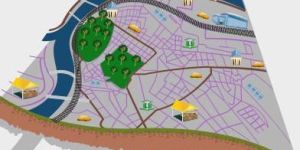
“esurvey topodraw” generates topographical drawings from point data instantly with blocks and elevations in their respective northing and easting from the data available in excel or csv.
Key features:
import point data(serial number, easting, northing, elevation, code) from csv or excel for generating topographical drawing
import predefined or newly defined blocks automatically while creating drawing
export codes point data in different layer selectively
create total station data from cad drawing
selectively auto connect codes in cad
benefits:
save considerable time while generating drawing from field data.
Detailed layerised output helps to process the drawing easily.
We offer topographic software.
“esurvey topodraw” generates topographical drawings from point data instantly with blocks and elevations in their respective northing and easting from the data available in excel or csv.
Key features:
import point data(serial number, easting, northing, elevation, code) from csv or excel for generating topographical drawing
import predefined or newly defined blocks automatically while creating drawing
export codes point data in different layer selectively
create total station data from cad drawing
selectively auto connect codes in cad
benefits:
save considerable time while generating drawing from field data.
Detailed layerised output helps to process the drawing easily.
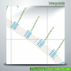
We are offering e survey interpolation software.
“esurvey interpolate” allows obtaining values at regular intervals.
it interpolates elevations at each cross section along the longitudinal section, which may further be exported to excel for section generation. Practically, surveying at regular intervals is not possible for various reasons. Thus, to obtain values at regular intervals, points are interpolated. This interpolation is often done manually with a lot of calculations. To address this issue, interpolate has been developed. It interpolates elevations at each cross section along longitudinal section, which may further be exported to excel for section generation. It also uses the three most commonly used and proven methods of interpolation techniques for data processing - straight line, tin or 3d interpolation.
key features:
interpolation along an alignment using any of the three methods – straight line, tin or 3d interpolation.
create 3d polylines by selecting elevation texts.
exports interpolated cross section and longitudinal section values to excel or section generation software.
benefits:
interpolate values quickly at required points on a surface without getting into complex surface building techniques.
...more
Interpolation Software
12,000 / Piece
We are offering e survey interpolation software.
“esurvey interpolate” allows obtaining values at regular intervals.
it interpolates elevations at each cross section along the longitudinal section, which may further be exported to excel for section generation. Practically, surveying at regular intervals is not possible for various reasons. Thus, to obtain values at regular intervals, points are interpolated. This interpolation is often done manually with a lot of calculations. To address this issue, interpolate has been developed. It interpolates elevations at each cross section along longitudinal section, which may further be exported to excel for section generation. It also uses the three most commonly used and proven methods of interpolation techniques for data processing - straight line, tin or 3d interpolation.
key features:
interpolation along an alignment using any of the three methods – straight line, tin or 3d interpolation.
create 3d polylines by selecting elevation texts.
exports interpolated cross section and longitudinal section values to excel or section generation software.
benefits:
interpolate values quickly at required points on a surface without getting into complex surface building techniques.
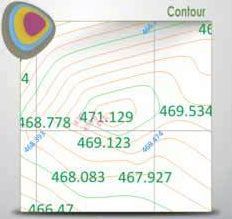
We are offering contour software.
esurvey contours
generates smooth contours quickly from point data available in cad drawings levels available in excel or csv files. It includes
key features:
import data from csv, excel or cad for contour generation
generate contours directly within cad
draw section for any alignment fixed on the contour map
generate contour area and contour volume instantly
generate boundary based contours
generate contours for specific levels
generate grid elevations or block levels
annotate contours:
at endpoints
at mid-points
at selected points
at specified intervals
draw grid elevations from existing contours
detailed layerisation before exporting to cad
benefits:
no necessity of creating terrain for contour generation
quick and smooth contours
lightweight contours thereby reducing the drawing file size
generate boundary, grid elevation, grid annotation, contours, contour annotation in single step.
use esurvey cad irrespective of your cad package as esurvey cad works with autocad® zw cad bricscad ares progecadgstarcad
...more
Contour Software
12,000 / Pack
We are offering contour software.
esurvey contours
generates smooth contours quickly from point data available in cad drawings levels available in excel or csv files. It includes
key features:
import data from csv, excel or cad for contour generation
generate contours directly within cad
draw section for any alignment fixed on the contour map
generate contour area and contour volume instantly
generate boundary based contours
generate contours for specific levels
generate grid elevations or block levels
annotate contours:
at endpoints
at mid-points
at selected points
at specified intervals
draw grid elevations from existing contours
detailed layerisation before exporting to cad
benefits:
no necessity of creating terrain for contour generation
quick and smooth contours
lightweight contours thereby reducing the drawing file size
generate boundary, grid elevation, grid annotation, contours, contour annotation in single step.
use esurvey cad irrespective of your cad package as esurvey cad works with autocad® zw cad bricscad ares progecadgstarcad