
Topographic Mapping
Get Price Quote
Topographic Mapping
Get Price Quote
 +2
+2
Map Dispensing System
Get Price Quote
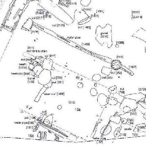
Survey Mapping
Get Price Quote
Survey Mapping
Get Price Quote
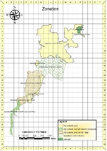
Vegetation Mapping Services
Get Price Quote

Hotel Mapping
Get Price Quote

Parcel Mapping Services
Get Price Quote

Gis Mapping
Get Price Quote

Drone Survey Mapping Service
Get Price Quote

Survey Mapping Service
Get Price Quote

Competency Mapping
Get Price Quote

3D City Mapping
Get Price Quote
Temperature Mapping Services
Get Price Quote
 +3
+3
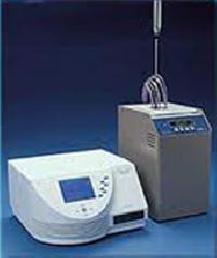
Temperature Mapping and Validation Services
Get Price Quote

GIS and Mapping Services
Get Price Quote
Market Mapping Services
Get Price Quote

GIS Mapping Service
1,000 - 1,500 / Acre

GIS Mapping Service
Get Price Quote

Route Mapping And Surveys Service
Get Price Quote

Noise Mapping
Get Price Quote

Utility GIS Mapping
Get Price Quote

GIS Mapping Services in India
Get Price Quote
 +1
+1
Survey Mapping Service
Get Price Quote

Map Dispensing System
Get Price Quote

Road Mapping Service
Get Price Quote

Port Mapping with 1G
Get Price Quote

Vector Maps
Get Price Quote

Gis Mapping Services
Get Price Quote

Temperature Mapping Services
1,200 - 2,000 / one


