Lucknow Land Surveyors Kursi Road, Lucknow, Uttar Pradesh

4.7 6 Reviews
GST Number : 09KKLPK8365P1ZU
Contact Us Request A Quote
  • Water Body Surveyor

    Water Body Surveyor

    Get Latest Price

    Water Body Surveyor – Accurate Surveying & Mapping of Water Resources   A Water Body Surveyor specializes in surveying and mapping natural and man-made water bodies such as rivers, lakes, ponds, reservoirs, wetlands, and canals. These surveys are essential for water resource management, irrigation projects, flood control, aquaculture, urban planning, and environmental conservation. By providing accurate data on size, depth, boundaries, and storage capacity, water body surveyors help governments, developers, and communities make informed decisions about water usage and sustainability.     Using advanced technologies like DGPS, Total Station, Drones, Bathymetric Equipment, and GIS Mapping, surveyors capture precise measurements of water spread area, depth profiles, and surrounding topography. This data is further processed into digital maps, 3D models, and CAD drawings for planning, analysis, and legal documentation.     Key Services of a Water Body Surveyor: Boundary Demarcation: Identifying legal limits of water bodies to prevent encroachment.   Hydrographic & Bathymetric Surveys: Measuring water depths and silt levels.   Capacity Estimation: Calculating storage potential for drinking water, irrigation, or industrial use.   Environmental Monitoring: Assessing siltation, water quality, and ecological balance.   Restoration Planning: Providing technical inputs for desilting, embankment strengthening, and conservation projects.        
    ...more
  • Water Body Surveyor

    Water Body Surveyor

    Request for Price

    Water Body Surveyor – Accurate Surveying & Mapping of Water Resources   A Water Body Surveyor specializes in surveying and mapping natural and man-made water bodies such as rivers, lakes, ponds, reservoirs, wetlands, and canals. These surveys are essential for water resource management, irrigation projects, flood control, aquaculture, urban planning, and environmental conservation. By providing accurate data on size, depth, boundaries, and storage capacity, water body surveyors help governments, developers, and communities make informed decisions about water usage and sustainability.     Using advanced technologies like DGPS, Total Station, Drones, Bathymetric Equipment, and GIS Mapping, surveyors capture precise measurements of water spread area, depth profiles, and surrounding topography. This data is further processed into digital maps, 3D models, and CAD drawings for planning, analysis, and legal documentation.     Key Services of a Water Body Surveyor: Boundary Demarcation: Identifying legal limits of water bodies to prevent encroachment.   Hydrographic & Bathymetric Surveys: Measuring water depths and silt levels.   Capacity Estimation: Calculating storage potential for drinking water, irrigation, or industrial use.   Environmental Monitoring: Assessing siltation, water quality, and ecological balance.   Restoration Planning: Providing technical inputs for desilting, embankment strengthening, and conservation projects.        

    ...more
    Get Best Price
  • Total Station Surveyor

    Total Station Surveyor

    Get Latest Price

    Total Station Surveyor – Precision Surveying with Advanced Instruments   A Total Station Surveyor is a professional who uses advanced electronic surveying instruments known as Total Stations to measure angles, distances, and elevations with high accuracy. These surveyors play a vital role in land development, construction, infrastructure projects, and property documentation by delivering precise survey data and digital maps.   The Total Station integrates electronic distance measurement (EDM), angle measurement, and data recording, allowing surveyors to collect field data quickly and accurately. A Total Station Surveyor can generate detailed topographic maps, 3D terrain models, and CAD-based layouts, which are crucial for engineering design and project execution.   Key Applications of Total Station Surveys:   Land & Property Surveys: Accurate boundary marking and legal documentation. Construction Layouts: Aligning foundations, columns, roads, and utilities. Topographic & Contour Mapping: Recording terrain levels for planning. Infrastructure Projects: Supporting roads, bridges, railways, pipelines, and drainage systems. Volume Calculations: Estimating earthwork for excavation and embankments.   Hiring a professional Total Station Surveyor ensures speed, accuracy, and efficiency compared to traditional survey methods. Their data eliminates manual errors, saves time, and provides precise inputs for architects, engineers, and developers. Total Station surveys are also widely accepted for government approvals, legal disputes, and land registration due to their reliability.    
    ...more
  • Total Station Surveyor

    Total Station Surveyor

    Request for Price

    Total Station Surveyor – Precision Surveying with Advanced Instruments   A Total Station Surveyor is a professional who uses advanced electronic surveying instruments known as Total Stations to measure angles, distances, and elevations with high accuracy. These surveyors play a vital role in land development, construction, infrastructure projects, and property documentation by delivering precise survey data and digital maps.   The Total Station integrates electronic distance measurement (EDM), angle measurement, and data recording, allowing surveyors to collect field data quickly and accurately. A Total Station Surveyor can generate detailed topographic maps, 3D terrain models, and CAD-based layouts, which are crucial for engineering design and project execution.   Key Applications of Total Station Surveys:   Land & Property Surveys: Accurate boundary marking and legal documentation. Construction Layouts: Aligning foundations, columns, roads, and utilities. Topographic & Contour Mapping: Recording terrain levels for planning. Infrastructure Projects: Supporting roads, bridges, railways, pipelines, and drainage systems. Volume Calculations: Estimating earthwork for excavation and embankments.   Hiring a professional Total Station Surveyor ensures speed, accuracy, and efficiency compared to traditional survey methods. Their data eliminates manual errors, saves time, and provides precise inputs for architects, engineers, and developers. Total Station surveys are also widely accepted for government approvals, legal disputes, and land registration due to their reliability.    

    ...more
    Get Best Price
  • Topographical Survey

    Topographical Survey

    Get Latest Price

      Topographical Survey – Detailed Mapping of Land Features   A Topographical Survey is a specialized land survey that records natural and man-made features of terrain, including elevations, contours, trees, roads, buildings, utilities, water bodies, and boundaries. It provides a detailed map of the existing ground surface, essential for planning and design of construction and infrastructure projects.   Using instruments such as otal Station, DGPS, Auto Level, Drone Mapping, and GIS technology, surveyors collect precise data points across the site. The data is then processed into topographic maps, contour drawings, and 3D models, forming the foundation for project decision-making.   Key Applications of Topographical Survey:   Urban Planning & Real Estate: Mapping plots, colonies, and housing layouts. Roads, Bridges & Highways: Designing alignment and drainage based on terrain levels. Water Resource Projects: Surveying canals, ponds, lakes, and catchment areas. Industrial & Infrastructure Development: Planning factories, power plants, and utilities. Environmental & Landscape Design: Recording vegetation, slopes, and ecological features.   A professional topographical survey ensures accurate, detailed, and compliant survey data, helping avoid construction errors, reduce costs, obtain legal approvals, and support dispute resolution.      
    ...more
  • Topographical Survey

    Topographical Survey

    Request for Price

      Topographical Survey – Detailed Mapping of Land Features   A Topographical Survey is a specialized land survey that records natural and man-made features of terrain, including elevations, contours, trees, roads, buildings, utilities, water bodies, and boundaries. It provides a detailed map of the existing ground surface, essential for planning and design of construction and infrastructure projects.   Using instruments such as otal Station, DGPS, Auto Level, Drone Mapping, and GIS technology, surveyors collect precise data points across the site. The data is then processed into topographic maps, contour drawings, and 3D models, forming the foundation for project decision-making.   Key Applications of Topographical Survey:   Urban Planning & Real Estate: Mapping plots, colonies, and housing layouts. Roads, Bridges & Highways: Designing alignment and drainage based on terrain levels. Water Resource Projects: Surveying canals, ponds, lakes, and catchment areas. Industrial & Infrastructure Development: Planning factories, power plants, and utilities. Environmental & Landscape Design: Recording vegetation, slopes, and ecological features.   A professional topographical survey ensures accurate, detailed, and compliant survey data, helping avoid construction errors, reduce costs, obtain legal approvals, and support dispute resolution.      

    ...more
    Get Best Price
  • Top Land Surveyor

    Top Land Surveyor

    Get Latest Price

    A Top Land Surveyor delivers precise land measurement, boundary demarcation, and mapping services using advanced tools such as GPS, DGPS, Total Stations, and drones. Trusted by builders, developers, and property owners for accurate surveys, legal compliance, and seamless project execution.
    ...more
  • Top Land Surveyor

    Top Land Surveyor

    Request for Price

    A Top Land Surveyor delivers precise land measurement, boundary demarcation, and mapping services using advanced tools such as GPS, DGPS, Total Stations, and drones. Trusted by builders, developers, and property owners for accurate surveys, legal compliance, and seamless project execution.

    ...more
    Get Best Price
  • Survey Mapping

    Survey Mapping

    Get Latest Price

    Survey Mapping – Accurate, Reliable & High-Precision Mapping Solutions Survey mapping is the process of collecting, analyzing, and presenting geographical data to create detailed maps and layouts of land, infrastructure, and terrain features. It plays a critical role in urban planning, construction, land development, agriculture, mining, and infrastructure projects. Accurate survey mapping ensures informed decision-making, legal compliance, and efficient project execution. At Lucknow Land Surveyors, we provide professional survey mapping services using advanced tools such as Total Stations, DGPS, LiDAR, UAV (Drone) Mapping, and GIS software. Our experienced surveyors deliver high-precision maps for a wide range of applications, including:   Topographic surveys Land boundary and cadastral mapping Contour and elevation mapping Utility and infrastructure mapping Route alignment for roads, railways, and pipelines Site layout and planning maps Whether you are a government agency, construction company, real estate developer, or engineering consultant, our survey mapping solutions are designed to meet your specific project requirements with accuracy and reliability.  
    ...more
  • Survey Mapping

    Survey Mapping

    Request for Price

    Survey Mapping – Accurate, Reliable & High-Precision Mapping Solutions Survey mapping is the process of collecting, analyzing, and presenting geographical data to create detailed maps and layouts of land, infrastructure, and terrain features. It plays a critical role in urban planning, construction, land development, agriculture, mining, and infrastructure projects. Accurate survey mapping ensures informed decision-making, legal compliance, and efficient project execution. At Lucknow Land Surveyors, we provide professional survey mapping services using advanced tools such as Total Stations, DGPS, LiDAR, UAV (Drone) Mapping, and GIS software. Our experienced surveyors deliver high-precision maps for a wide range of applications, including:   Topographic surveys Land boundary and cadastral mapping Contour and elevation mapping Utility and infrastructure mapping Route alignment for roads, railways, and pipelines Site layout and planning maps Whether you are a government agency, construction company, real estate developer, or engineering consultant, our survey mapping solutions are designed to meet your specific project requirements with accuracy and reliability.  

    ...more
    Get Best Price
  • Solar Panel Survey

    Solar Panel Survey

    Get Latest Price

    Solar Panel Survey is the first and most important step before installing a solar energy system. It involves a detailed assessment of the site to determine its suitability for solar panels, ensuring maximum efficiency, safety, and return on investment. A professional solar panel surveyor evaluates roof conditions, shading, structural strength, and available space to design the best solar layout.Using advanced tools like GPS, Total Station, Drone Mapping, and Solar Analysis Software, surveyors provide accurate measurements and data on roof orientation, tilt angle, and sunlight exposure. This data helps in optimizing solar panel placement for maximum energy generation.   Key aspects of a Solar Panel Survey include:   Site Assessment: Evaluating roof or ground space, structural safety, and load capacity. Shading Analysis: Checking nearby trees, buildings, or obstacles that may block sunlight. Solar Mapping & Layout Design: Planning the ideal position, direction, and tilt for panels. Electrical Feasibility: Assessing wiring routes, inverter placement, and connection to the grid. Cost & Efficiency Estimation: Providing accurate projections of power output and savings.      
    ...more
  • Solar Panel Survey

    Solar Panel Survey

    Request for Price

    Solar Panel Survey is the first and most important step before installing a solar energy system. It involves a detailed assessment of the site to determine its suitability for solar panels, ensuring maximum efficiency, safety, and return on investment. A professional solar panel surveyor evaluates roof conditions, shading, structural strength, and available space to design the best solar layout.Using advanced tools like GPS, Total Station, Drone Mapping, and Solar Analysis Software, surveyors provide accurate measurements and data on roof orientation, tilt angle, and sunlight exposure. This data helps in optimizing solar panel placement for maximum energy generation.   Key aspects of a Solar Panel Survey include:   Site Assessment: Evaluating roof or ground space, structural safety, and load capacity. Shading Analysis: Checking nearby trees, buildings, or obstacles that may block sunlight. Solar Mapping & Layout Design: Planning the ideal position, direction, and tilt for panels. Electrical Feasibility: Assessing wiring routes, inverter placement, and connection to the grid. Cost & Efficiency Estimation: Providing accurate projections of power output and savings.      

    ...more
    Get Best Price
  • Road Surveyor

    Road Surveyor

    Get Latest Price

    Road Surveyor – Precision Surveys for Road & Highway Projects   A Road Surveyor plays a key role in the planning, design, and construction of roads, highways, and expressways. Their primary responsibility is to conduct detailed surveys that provide accurate data on land levels, alignment, gradients, and terrain conditions, which is crucial for engineers and planners to design cost-effective, safe, and durable road networks.   Using advanced instruments such as Total Stations, GPS/DGPS, Auto Levels, Drones, and GIS Mapping, road surveyors collect precise measurements of the land. These surveys include topographic mapping, contour studies, cross-section, and longitudinal profiles, vital for road alignment and construction planning.   Key Tasks of a Road Surveyor:   Route Alignment Surveys: Identifying the most suitable path for roads or highways. Topographic & Contour Mapping: Recording terrain elevations for accurate design. Earthwork & Volume Calculations: Estimating cut and fill quantities for construction. Construction Layout: Marking center lines, curves, slopes, and levels on-site. Quality & Compliance Checks: Ensuring road projects follow engineering and government standards.   Road surveyors work closely with civil engineers, contractors, and government authorities to deliver reliable data that supports both new road construction and maintenance projects, reducing errors, minimizing costs, and ensuring long-lasting infrastructure.        
    ...more
  • Road Surveyor

    Road Surveyor

    Request for Price

    Road Surveyor – Precision Surveys for Road & Highway Projects   A Road Surveyor plays a key role in the planning, design, and construction of roads, highways, and expressways. Their primary responsibility is to conduct detailed surveys that provide accurate data on land levels, alignment, gradients, and terrain conditions, which is crucial for engineers and planners to design cost-effective, safe, and durable road networks.   Using advanced instruments such as Total Stations, GPS/DGPS, Auto Levels, Drones, and GIS Mapping, road surveyors collect precise measurements of the land. These surveys include topographic mapping, contour studies, cross-section, and longitudinal profiles, vital for road alignment and construction planning.   Key Tasks of a Road Surveyor:   Route Alignment Surveys: Identifying the most suitable path for roads or highways. Topographic & Contour Mapping: Recording terrain elevations for accurate design. Earthwork & Volume Calculations: Estimating cut and fill quantities for construction. Construction Layout: Marking center lines, curves, slopes, and levels on-site. Quality & Compliance Checks: Ensuring road projects follow engineering and government standards.   Road surveyors work closely with civil engineers, contractors, and government authorities to deliver reliable data that supports both new road construction and maintenance projects, reducing errors, minimizing costs, and ensuring long-lasting infrastructure.        

    ...more
    Get Best Price
  • Railway Track Survey

    Railway Track Survey

    6,000 - 8,000 / Day

    Railway Track Survey – Precision Planning & Mapping for Rail Infrastructure   A Railway Track Survey is a highly specialized survey conducted for the planning, design, construction, and maintenance of railway lines. It involves precise measurement and mapping of terrain to determine the most feasible and cost-effective alignment for tracks. Railway surveys ensure **safety, durability, and efficiency while complying with *engineering standards and government regulations.     Using advanced instruments such as Total Station, DGPS, Auto Level, Drone Mapping, and GIS technology, railway surveyors record data on ground levels, curves, gradients, and obstacles. This data is used to create topographic maps, alignment drawings, longitudinal and cross-sectional profiles, forming the foundation of railway engineering.     Key Applications of Railway Track Survey: Route Selection & Alignment: Identifying the shortest, safest, and most economical path.   Earthwork Estimation: Calculating cut-and-fill quantities for track beds and embankments.   Bridge & Tunnel Planning: Surveying terrain for supporting structures.   Track Upgradation: Assessing existing lines for gauge conversion or capacity enhancement.   Drainage & Safety Checks: Designing proper slopes to prevent waterlogging and accidents.     Railway track surveys are essential for new railway lines, metro projects, high-speed corridors, freight corridors, and station expansions. They provide accurate data that helps engineers reduce construction costs, ensure smooth train movement, and minimize long-term maintenance.      
    ...more
  • Railway Track Survey

    Railway Track Survey

    6,000 - 8,000 / Day

    Railway Track Survey – Precision Planning & Mapping for Rail Infrastructure   A Railway Track Survey is a highly specialized survey conducted for the planning, design, construction, and maintenance of railway lines. It involves precise measurement and mapping of terrain to determine the most feasible and cost-effective alignment for tracks. Railway surveys ensure **safety, durability, and efficiency while complying with *engineering standards and government regulations.     Using advanced instruments such as Total Station, DGPS, Auto Level, Drone Mapping, and GIS technology, railway surveyors record data on ground levels, curves, gradients, and obstacles. This data is used to create topographic maps, alignment drawings, longitudinal and cross-sectional profiles, forming the foundation of railway engineering.     Key Applications of Railway Track Survey: Route Selection & Alignment: Identifying the shortest, safest, and most economical path.   Earthwork Estimation: Calculating cut-and-fill quantities for track beds and embankments.   Bridge & Tunnel Planning: Surveying terrain for supporting structures.   Track Upgradation: Assessing existing lines for gauge conversion or capacity enhancement.   Drainage & Safety Checks: Designing proper slopes to prevent waterlogging and accidents.     Railway track surveys are essential for new railway lines, metro projects, high-speed corridors, freight corridors, and station expansions. They provide accurate data that helps engineers reduce construction costs, ensure smooth train movement, and minimize long-term maintenance.      

    ...more
    Get Best Price
  • Quantity Surveyor

    Quantity Surveyor

    Get Latest Price

    A Quantity Surveyor specializes in cost estimation, project budgeting, and financial management for construction projects. They ensure accurate material take-offs, tendering, and cost control, helping developers, contractors, and clients deliver quality projects within budget and on time.      
    ...more
  • Quantity Surveyor

    Quantity Surveyor

    Request for Price

    A Quantity Surveyor specializes in cost estimation, project budgeting, and financial management for construction projects. They ensure accurate material take-offs, tendering, and cost control, helping developers, contractors, and clients deliver quality projects within budget and on time.      

    ...more
    Get Best Price
  • Property Surveyor

    Property Surveyor

    Get Latest Price

    A Property Surveyor provides accurate land measurement, boundary marking, and legal verification services. They ensure clear property ownership, prevent disputes, and support construction, buying, or selling. Trusted for delivering precise property and land survey solutions.
    ...more
  • Property Surveyor

    Property Surveyor

    Request for Price

    A Property Surveyor provides accurate land measurement, boundary marking, and legal verification services. They ensure clear property ownership, prevent disputes, and support construction, buying, or selling. Trusted for delivering precise property and land survey solutions.

    ...more
    Get Best Price
  • Pond Lake Surveyor

    Pond Lake Surveyor

    Get Latest Price

    • TypeWater Body Survey Services
    • ApplicationWater Resource Management, Environmental Studies, Aquaculture, Irrigation Planning, Urban Development Projects
    • Specialized EquipmentDGPS, Total Station, Echo Sounders, Drone Technology, GIS Mapping
    • Survey ProcessHydrographic Surveying: Measuring Water Depth And Preparing Bathymetric Maps.,Boundary Demarcation: Identifying Legal Limits Of Ponds And Lakes To Prevent Encroach,Topographic & Contour Mapping: Documenting Surrounding Terrain For Watershed Planning And F
    • Service ModeOn Site
    • Pond & Lake Surveyor – Specialized Water Body Survey Services   A Pond & Lake Surveyor specializes in the measurement, mapping, and analysis of natural and man-made water bodies such as ponds, lakes, reservoirs, and wetlands. These surveys are vital for water resource management, environmental studies, aquaculture, irrigation planning, and urban development projects.   Using advanced instruments like DGPS, Total Station, Echo Sounders, Drone Technology, and GIS Mapping, pond and lake surveyors deliver accurate data on **water spread area, depth, storage capacity, and shoreline boundaries   Survey Process Includes:   Hydrographic Surveying: Measuring water depth and preparing bathymetric maps. Boundary Demarcation: Identifying legal limits of ponds and lakes to prevent encroachTopographic & Contour Mapping: Documenting surrounding terrain for watershed planning and flood control. Capacity Estimation: Calculating storage potential for irrigation, aquaculture, or municipal water supply. Environmental Assessments:Monitoring siltation, water quality, and ecological balance.      
    ...more
  • Pond Lake Surveyor

    Pond Lake Surveyor

    Request for Price

    Pond & Lake Surveyor – Specialized Water Body Survey Services   A Pond & Lake Surveyor specializes in the measurement, mapping, and analysis of natural and man-made water bodies such as ponds, lakes, reservoirs, and wetlands. These surveys are vital for water resource management, environmental studies, aquaculture, irrigation planning, and urban development projects.   Using advanced instruments like DGPS, Total Station, Echo Sounders, Drone Technology, and GIS Mapping, pond and lake surveyors deliver accurate data on **water spread area, depth, storage capacity, and shoreline boundaries   Survey Process Includes:   Hydrographic Surveying: Measuring water depth and preparing bathymetric maps. Boundary Demarcation: Identifying legal limits of ponds and lakes to prevent encroachTopographic & Contour Mapping: Documenting surrounding terrain for watershed planning and flood control. Capacity Estimation: Calculating storage potential for irrigation, aquaculture, or municipal water supply. Environmental Assessments:Monitoring siltation, water quality, and ecological balance.      

    Type : Water Body Survey Services

    ...more
    Get Best Price
  • nabl testing sbc service

    nabl testing sbc service

    800 - 1,200 / Meter

    NABL Testing refers to testing services accredited by the National Accreditation Board for Testing and Calibration Laboratories (NABL), an autonomous body under the Department of Science and Technology, Government of India. NABL accreditation signifies that a testing laboratory meets specific international standards and has demonstrated competence and capability in conducting accurate and reliable testing across various fields. Key features of NABL Testing services include: Accreditation Assurance: NABL is the premier accreditation body in India, and laboratories accredited by NABL adhere to stringent quality standards, ensuring the reliability and credibility of their testing services. Compliance with Standards: NABL-accredited laboratories follow recognized international standards and guidelines for testing methodologies, ensuring that their procedures are in line with global best practices. Scope of Testing: NABL-accredited laboratories cover a wide range of testing services across industries such as healthcare, environment, food and agriculture, construction, electronics, and more. Technical Competence: Laboratories with NABL accreditation demonstrate technical competence in their specific testing domain. This involves having qualified personnel, appropriate equipment, and well-documented procedures. Quality Management System: NABL requires accredited laboratories to implement a robust Quality Management System (QMS) to ensure the consistency and reliability of testing processes. Calibration Services: NABL-accredited laboratories often provide calibration services, ensuring that measurement instruments and equipment are accurate and traceable to international standards. Client Confidence: NABL accreditation enhances client confidence in the accuracy and reliability of testing results. Many organizations, industries, and regulatory bodies recognize and prefer results from NABL-accredited laboratories. Continuous Improvement: Accredited laboratories are committed to continuous improvement. Regular assessments by NABL ensure that laboratories maintain high standards and stay abreast of advancements in testing methodologies. Industry Recognition: NABL accreditation is widely recognized and accepted in various industries, facilitating international trade and compliance with regulatory requirements. Traceability and Transparency: NABL-accredited laboratories ensure traceability of measurements and provide transparent reporting, enabling clients to trust and understand the testing processes. Whether it's testing the safety of food products, evaluating the quality of construction materials, or ensuring the accuracy of medical diagnostics, NABL Testing services play a crucial role in diverse sectors by providing reliable and standardized testing solutions.
    ...more
  • nabl testing sbc service

    nabl testing sbc service

    800 - 1,200 / Meter

    NABL Testing refers to testing services accredited by the National Accreditation Board for Testing and Calibration Laboratories (NABL), an autonomous body under the Department of Science and Technology, Government of India. NABL accreditation signifies that a testing laboratory meets specific international standards and has demonstrated competence and capability in conducting accurate and reliable testing across various fields. Key features of NABL Testing services include: Accreditation Assurance: NABL is the premier accreditation body in India, and laboratories accredited by NABL adhere to stringent quality standards, ensuring the reliability and credibility of their testing services. Compliance with Standards: NABL-accredited laboratories follow recognized international standards and guidelines for testing methodologies, ensuring that their procedures are in line with global best practices. Scope of Testing: NABL-accredited laboratories cover a wide range of testing services across industries such as healthcare, environment, food and agriculture, construction, electronics, and more. Technical Competence: Laboratories with NABL accreditation demonstrate technical competence in their specific testing domain. This involves having qualified personnel, appropriate equipment, and well-documented procedures. Quality Management System: NABL requires accredited laboratories to implement a robust Quality Management System (QMS) to ensure the consistency and reliability of testing processes. Calibration Services: NABL-accredited laboratories often provide calibration services, ensuring that measurement instruments and equipment are accurate and traceable to international standards. Client Confidence: NABL accreditation enhances client confidence in the accuracy and reliability of testing results. Many organizations, industries, and regulatory bodies recognize and prefer results from NABL-accredited laboratories. Continuous Improvement: Accredited laboratories are committed to continuous improvement. Regular assessments by NABL ensure that laboratories maintain high standards and stay abreast of advancements in testing methodologies. Industry Recognition: NABL accreditation is widely recognized and accepted in various industries, facilitating international trade and compliance with regulatory requirements. Traceability and Transparency: NABL-accredited laboratories ensure traceability of measurements and provide transparent reporting, enabling clients to trust and understand the testing processes. Whether it's testing the safety of food products, evaluating the quality of construction materials, or ensuring the accuracy of medical diagnostics, NABL Testing services play a crucial role in diverse sectors by providing reliable and standardized testing solutions.

    ...more
    Get Best Price
  • Marine Surveyor

    Marine Surveyor

    Get Latest Price

    Marine Surveyor inspects ships, boats, and marine equipment to ensure safety, seaworthiness, and regulatory compliance. They assess vessel condition, cargo handling, and maintenance, providing detailed reports, certifications, and recommendations for repairs or improvements to owners, insurers, and maritime authorities.  
    ...more
  • Marine Surveyor

    Marine Surveyor

    Request for Price

    Marine Surveyor inspects ships, boats, and marine equipment to ensure safety, seaworthiness, and regulatory compliance. They assess vessel condition, cargo handling, and maintenance, providing detailed reports, certifications, and recommendations for repairs or improvements to owners, insurers, and maritime authorities.  

    ...more
    Get Best Price
  • Layout Survey

    Layout Survey

    5,000 - 8,000 / visit

    Layout Survey – Accurate On-Site Transfer of Plans   Layout Survey is an essential step in land development and construction projects, involving the accurate transfer of approved building or site plans onto the ground. It ensures that plots, roads, utilities, and structures are positioned exactly as per the architectural and engineering drawings. Layout surveys serve as the foundation for **error-free construction, legal compliance, and efficient land utilization.   Using advanced surveying instruments like Total Station, DGPS, Auto Level, and GPS equipment, professional surveyors mark reference points, grid lines, and dimensions on-site with high accuracy. The process includes boundary verification, alignment checks, and positioning of columns, foundations, and utilities, ensuring that the development matches approved designs.   Key Applications of Layout Surveys:   Residential & Commercial Layouts: Marking plots, roads, and open spaces. Townships & Housing Projects: Ensuring proper division of land as per authority approvals. Industrial & Institutional Projects: Positioning structures and utilities with precision. Construction Works: Transferring grid lines for columns, foundations, and walls. Government Compliance: Meeting standards set by municipal and development authorities.   A layout survey prevents misalignment, boundary disputes, and construction errors saving both time and cost. It also provides developers with accurate site records, which help in property sales, approvals, and long-term project management.   Whether for real estate plotting, township planning, or commercial and industrial development, hiring a professional Layout Surveyor ensures accuracy, transparency, and smooth execution**.    
    ...more
  • Layout Survey

    Layout Survey

    5,000 - 8,000 / visit

    Layout Survey – Accurate On-Site Transfer of Plans   Layout Survey is an essential step in land development and construction projects, involving the accurate transfer of approved building or site plans onto the ground. It ensures that plots, roads, utilities, and structures are positioned exactly as per the architectural and engineering drawings. Layout surveys serve as the foundation for **error-free construction, legal compliance, and efficient land utilization.   Using advanced surveying instruments like Total Station, DGPS, Auto Level, and GPS equipment, professional surveyors mark reference points, grid lines, and dimensions on-site with high accuracy. The process includes boundary verification, alignment checks, and positioning of columns, foundations, and utilities, ensuring that the development matches approved designs.   Key Applications of Layout Surveys:   Residential & Commercial Layouts: Marking plots, roads, and open spaces. Townships & Housing Projects: Ensuring proper division of land as per authority approvals. Industrial & Institutional Projects: Positioning structures and utilities with precision. Construction Works: Transferring grid lines for columns, foundations, and walls. Government Compliance: Meeting standards set by municipal and development authorities.   A layout survey prevents misalignment, boundary disputes, and construction errors saving both time and cost. It also provides developers with accurate site records, which help in property sales, approvals, and long-term project management.   Whether for real estate plotting, township planning, or commercial and industrial development, hiring a professional Layout Surveyor ensures accuracy, transparency, and smooth execution**.    

    ...more
    Get Best Price
  • Layout Plot Marking

    Layout Plot Marking

    5,000 - 15,000 / Day

      Layout Plot Marking – Accurate Land Division for Development Projects   Layout Plot Marking is a vital stage in land development, construction, and real estate projects. It involves the accurate division and marking of land into plots based on approved designs and legal documents. By using precise survey methods, layout plot marking ensures that each plot is properly aligned with roads, open spaces, utilities, and boundaries as per municipal or development authority guidelines.   Professional surveyors use Total Station, GPS/DGPS, Auto Level, and CAD software to mark plots with high accuracy. The process begins with detailed land measurement, followed by demarcation of roads, plot corners, and public spaces. Each plot is marked with permanent reference points or pegs, which serve as the foundation for future construction.   Key Benefits and Applications of Layout Plot Marking:   Residential & Commercial Projects: Dividing large land parcels into legally approved plots. Township & Housing Colonies:Ensuring roads, amenities, and open spaces are correctly aligned. Industrial Layouts: Marking factory plots, internal roads, and utility zones. Compliance with Authorities: Preparing layouts that meet LDA, RERA, or municipal standards. Legal & Transparent Transactions: Providing clear plot boundaries for buyers and developers.   Accurate layout plot marking prevents boundary disputes, encroachments, and planning errors, making it a critical step in real estate development. It also helps developers showcase properly designed and approved layouts to potential buyers, increasing trust and property value.      
    ...more
  • Layout Plot Marking

    Layout Plot Marking

    5,000 - 15,000 / Day

      Layout Plot Marking – Accurate Land Division for Development Projects   Layout Plot Marking is a vital stage in land development, construction, and real estate projects. It involves the accurate division and marking of land into plots based on approved designs and legal documents. By using precise survey methods, layout plot marking ensures that each plot is properly aligned with roads, open spaces, utilities, and boundaries as per municipal or development authority guidelines.   Professional surveyors use Total Station, GPS/DGPS, Auto Level, and CAD software to mark plots with high accuracy. The process begins with detailed land measurement, followed by demarcation of roads, plot corners, and public spaces. Each plot is marked with permanent reference points or pegs, which serve as the foundation for future construction.   Key Benefits and Applications of Layout Plot Marking:   Residential & Commercial Projects: Dividing large land parcels into legally approved plots. Township & Housing Colonies:Ensuring roads, amenities, and open spaces are correctly aligned. Industrial Layouts: Marking factory plots, internal roads, and utility zones. Compliance with Authorities: Preparing layouts that meet LDA, RERA, or municipal standards. Legal & Transparent Transactions: Providing clear plot boundaries for buyers and developers.   Accurate layout plot marking prevents boundary disputes, encroachments, and planning errors, making it a critical step in real estate development. It also helps developers showcase properly designed and approved layouts to potential buyers, increasing trust and property value.      

    ...more
    Get Best Price
  • Layout Designing Survey

    Layout Designing Survey

    Get Latest Price

    Layout Designing Survey – Accurate Planning for Residential, Commercial & Industrial Projects   A Layout Designing Survey is an essential step in the planning and development of residential, commercial, and industrial projects. It involves the precise measurement, division, and mapping of land into plots or sections according to approved design plans and legal regulations. This survey ensures accurate demarcation of boundaries, road alignments, open spaces, utility areas, and amenities, creating a clear and reliable blueprint for property developers, real estate companies, and landowners.   Using advanced instruments such as Total Stations, GPS/DGPS, Auto Levels, and Drone Technology, layout designing surveyors provide accurate data for drafting layouts that comply with local authority guidelines such as LDA (Lucknow Development Authority) approvals, RERA norms, and municipal standards. Proper layout planning not only enhances the functionality and aesthetics of a project but also ensures that land utilization is efficient, legally compliant, and future-ready.    
    ...more
  • Layout Designing Survey

    Layout Designing Survey

    Request for Price

    Layout Designing Survey – Accurate Planning for Residential, Commercial & Industrial Projects   A Layout Designing Survey is an essential step in the planning and development of residential, commercial, and industrial projects. It involves the precise measurement, division, and mapping of land into plots or sections according to approved design plans and legal regulations. This survey ensures accurate demarcation of boundaries, road alignments, open spaces, utility areas, and amenities, creating a clear and reliable blueprint for property developers, real estate companies, and landowners.   Using advanced instruments such as Total Stations, GPS/DGPS, Auto Levels, and Drone Technology, layout designing surveyors provide accurate data for drafting layouts that comply with local authority guidelines such as LDA (Lucknow Development Authority) approvals, RERA norms, and municipal standards. Proper layout planning not only enhances the functionality and aesthetics of a project but also ensures that land utilization is efficient, legally compliant, and future-ready.    

    ...more
    Get Best Price
  • Land Surveyor in Lucknow

    Land Surveyor in Lucknow

    Get Latest Price

    • NameLand Surveyor in Lucknow
    • NameLand surveyor
    • SizeLucknow
    • Best Land Surveyors in Lucknow
  • Land Surveyor in Lucknow

    Land Surveyor in Lucknow

    Request for Price

    Best Land Surveyors in Lucknow

    Get Best Price
  • Land Plotting Surveyor

    Land Plotting Surveyor

    Get Latest Price

    A Land Plotting Surveyor provides accurate measurement and division of land into plots for residential, commercial, or industrial use. They ensure precise boundaries, layout planning, and legal compliance, supporting real estate, construction, and property development projects.    
    ...more
  • Land Plotting Surveyor

    Land Plotting Surveyor

    Request for Price

    A Land Plotting Surveyor provides accurate measurement and division of land into plots for residential, commercial, or industrial use. They ensure precise boundaries, layout planning, and legal compliance, supporting real estate, construction, and property development projects.    

    ...more
    Get Best Price
  • Industrial Land Surveyor

    Industrial Land Surveyor

    Get Latest Price

    Industrial Land Surveyor – Precision Surveys for Industrial Development   An Industrial Land Surveyor specializes in surveying land designated for factories, warehouses, manufacturing units, and large-scale industrial projects. Unlike standard property surveys, industrial land surveying demands a high level of precision to accommodate heavy infrastructure, machinery setups, transportation access, utility lines, and strict compliance with government regulations.   Using advanced technology such as **Total Station, GPS/DGPS, Drone Surveying, GIS Mapping, and AutoCAD Designing**, an industrial land surveyor provides accurate data on land boundaries, topography, elevation, and soil levels. This data is crucial for planning site layouts, designing internal roads, setting up drainage systems, and ensuring proper land utilization.   Key Services Offered by Industrial Land Surveyors:   Boundary & Demarcation Surveys: Establishing accurate legal property lines to prevent disputes. Topographic & Contour Surveys: Mapping terrain details for effective site planning and infrastructure design. Layout Designing: Preparing CAD-based layouts for factory plots, utility zones, parking areas, and internal access roads. Pipeline & Utility Surveys: Marking the alignment of water, electricity, and gas pipelines. Compliance & Approvals: Supporting documentation for industrial authorities, SEZs, and government approvals.    
    ...more
  • Industrial Land Surveyor

    Industrial Land Surveyor

    Request for Price

    Industrial Land Surveyor – Precision Surveys for Industrial Development   An Industrial Land Surveyor specializes in surveying land designated for factories, warehouses, manufacturing units, and large-scale industrial projects. Unlike standard property surveys, industrial land surveying demands a high level of precision to accommodate heavy infrastructure, machinery setups, transportation access, utility lines, and strict compliance with government regulations.   Using advanced technology such as **Total Station, GPS/DGPS, Drone Surveying, GIS Mapping, and AutoCAD Designing**, an industrial land surveyor provides accurate data on land boundaries, topography, elevation, and soil levels. This data is crucial for planning site layouts, designing internal roads, setting up drainage systems, and ensuring proper land utilization.   Key Services Offered by Industrial Land Surveyors:   Boundary & Demarcation Surveys: Establishing accurate legal property lines to prevent disputes. Topographic & Contour Surveys: Mapping terrain details for effective site planning and infrastructure design. Layout Designing: Preparing CAD-based layouts for factory plots, utility zones, parking areas, and internal access roads. Pipeline & Utility Surveys: Marking the alignment of water, electricity, and gas pipelines. Compliance & Approvals: Supporting documentation for industrial authorities, SEZs, and government approvals.    

    ...more
    Get Best Price
  • Highway Surveyor

    Highway Surveyor

    Get Latest Price

    Highway Surveyor – Precision in Road Network Development A highway surveyor plays a crucial role in the planning, designing, and construction of modern road networks. Highway surveying involves the precise measurement and mapping of land to determine the most suitable routes for highways, expressways, and road infrastructure projects. Using advanced instruments such as Total Stations, GPS/DGPS, Auto Levels, and drones, highway surveyors ensure accuracy in alignment, gradients, curves, and elevations—vital for smooth and safe road construction.   The survey process begins with reconnaissance and feasibility studies, where surveyors evaluate terrain, soil conditions, and existing obstacles. Detailed topographic and alignment surveys are then conducted to prepare contour maps, cross-sections, and longitudinal profiles. These surveys help engineers and planners design cost-effective and sustainable highways while minimizing environmental and social impacts.   Skilled highway surveyors also provide construction layout services, ensuring that designed plans are executed correctly on-site. They mark centerlines, levels, and boundaries required for excavation, embankments, pavement layers, bridges, culverts, and other road features. Their expertise supports seamless coordination between engineers, contractors, and government authorities.   Highway surveyors are also essential for road widening projects, bypass construction, hill road development, and maintenance surveys. By leveraging modern surveying technologies, they help reduce errors, save time, and enhance efficiency in highway development.      
    ...more
  • Highway Surveyor

    Highway Surveyor

    Request for Price

    Highway Surveyor – Precision in Road Network Development A highway surveyor plays a crucial role in the planning, designing, and construction of modern road networks. Highway surveying involves the precise measurement and mapping of land to determine the most suitable routes for highways, expressways, and road infrastructure projects. Using advanced instruments such as Total Stations, GPS/DGPS, Auto Levels, and drones, highway surveyors ensure accuracy in alignment, gradients, curves, and elevations—vital for smooth and safe road construction.   The survey process begins with reconnaissance and feasibility studies, where surveyors evaluate terrain, soil conditions, and existing obstacles. Detailed topographic and alignment surveys are then conducted to prepare contour maps, cross-sections, and longitudinal profiles. These surveys help engineers and planners design cost-effective and sustainable highways while minimizing environmental and social impacts.   Skilled highway surveyors also provide construction layout services, ensuring that designed plans are executed correctly on-site. They mark centerlines, levels, and boundaries required for excavation, embankments, pavement layers, bridges, culverts, and other road features. Their expertise supports seamless coordination between engineers, contractors, and government authorities.   Highway surveyors are also essential for road widening projects, bypass construction, hill road development, and maintenance surveys. By leveraging modern surveying technologies, they help reduce errors, save time, and enhance efficiency in highway development.      

    ...more
    Get Best Price
  • Ground Level Survey

    Ground Level Survey

    8,000 - 15,000 / visit

    • ApplicationBuilding construction, roads & highways, drainage, irrigation, landscaping, and plot development.
    • Service ModeOn-site
    • Survey TypeGround elevation, slope, contour, and topography survey
    • Technology UsedTotal Station, GPS/DGPS, Auto Level, Drone Mapping.
    • Ground Level Survey is a crucial part of land measurement and site preparation, carried out to record the natural surface levels of a plot or terrain. This survey provides accurate information on elevations, slopes, and contours, which is essential for construction, drainage design, landscaping, and infrastructure projects. Understanding the existing ground conditions allows engineers and architects to create designs that are both cost-effective and technically sound.   Using advanced instruments like Total Station, GPS/DGPS, Auto Level, and Drone Mapping, surveyors capture detailed data points across the site. These measurements are then converted into digital contour maps, longitudinal profiles, and cross-sections, forming the foundation for planning and design.   Key Applications of Ground Level Survey:   Building Construction: Ensuring correct foundation levels and site grading. Road & Highway Projects:Designing proper slopes, drainage, and alignment. Drainage & Irrigation: Planning water flow to prevent flooding or erosion. Landscape & Plot Development: Creating balanced and functional land use layouts. Earthwork Estimation: Calculating cut and fill volumes for excavation or embankment.   Ground level surveys are also important for legal and approval processes, providing reliable documentation for government authorities, developers, and contractors. By identifying natural undulations and height differences, these surveys help avoid costly errors during construction    
    ...more
  • Ground Level Survey

    Ground Level Survey

    8,000 - 15,000 / visit

    Ground Level Survey is a crucial part of land measurement and site preparation, carried out to record the natural surface levels of a plot or terrain. This survey provides accurate information on elevations, slopes, and contours, which is essential for construction, drainage design, landscaping, and infrastructure projects. Understanding the existing ground conditions allows engineers and architects to create designs that are both cost-effective and technically sound.   Using advanced instruments like Total Station, GPS/DGPS, Auto Level, and Drone Mapping, surveyors capture detailed data points across the site. These measurements are then converted into digital contour maps, longitudinal profiles, and cross-sections, forming the foundation for planning and design.   Key Applications of Ground Level Survey:   Building Construction: Ensuring correct foundation levels and site grading. Road & Highway Projects:Designing proper slopes, drainage, and alignment. Drainage & Irrigation: Planning water flow to prevent flooding or erosion. Landscape & Plot Development: Creating balanced and functional land use layouts. Earthwork Estimation: Calculating cut and fill volumes for excavation or embankment.   Ground level surveys are also important for legal and approval processes, providing reliable documentation for government authorities, developers, and contractors. By identifying natural undulations and height differences, these surveys help avoid costly errors during construction    

    Application : Building construction, roads & highways, drainage, irrigation, landscaping, and plot development.

    ...more
    Get Best Price
  • GIS Mapping Service

    GIS Mapping Service

    Get Latest Price

    GIS Mapping (Geographic Information System Mapping)** is a modern technology that captures, stores, analyzes, and visualizes spatial data to create highly accurate maps and models. It integrates geographic coordinates with descriptive information, making it an essential tool for urban planning, land management, infrastructure development, environmental monitoring, and resource management.   Using advanced tools like DGPS, Remote Sensing, Drones, and Satellite Imagery, GIS mapping provides detailed layers of information such as terrain features, land use patterns, utilities, roads, water bodies, and vegetation. These layers can be analyzed together to support decision-making for government bodies, engineers, developers, and researchers.   Key applications of GIS mapping include: Urban Planning & Smart Cities: Designing roads, utilities, and public infrastructure. Land & Property Management: Maintaining digital land records, boundary mapping, and ownership clarity. Environmental Monitoring: Tracking deforestation, pollution, and climate change impacts. Infrastructure Projects: Supporting roadways, pipelines, power lines, and railways. Disaster Management: Mapping flood zones, earthquake-prone areas, and emergency response planning. griculture & Irrigation: Soil analysis, crop monitoring, and water distribution planning.   GIS mapping is widely used by government agencies, surveyors, planners, engineers, and private organizations for its accuracy and efficiency. It not only reduces manual errors but also helps in predictive analysis, spatial planning, and real-time monitoring.  
    ...more
  • GIS Mapping Service

    GIS Mapping Service

    Request for Price

    GIS Mapping (Geographic Information System Mapping)** is a modern technology that captures, stores, analyzes, and visualizes spatial data to create highly accurate maps and models. It integrates geographic coordinates with descriptive information, making it an essential tool for urban planning, land management, infrastructure development, environmental monitoring, and resource management.   Using advanced tools like DGPS, Remote Sensing, Drones, and Satellite Imagery, GIS mapping provides detailed layers of information such as terrain features, land use patterns, utilities, roads, water bodies, and vegetation. These layers can be analyzed together to support decision-making for government bodies, engineers, developers, and researchers.   Key applications of GIS mapping include: Urban Planning & Smart Cities: Designing roads, utilities, and public infrastructure. Land & Property Management: Maintaining digital land records, boundary mapping, and ownership clarity. Environmental Monitoring: Tracking deforestation, pollution, and climate change impacts. Infrastructure Projects: Supporting roadways, pipelines, power lines, and railways. Disaster Management: Mapping flood zones, earthquake-prone areas, and emergency response planning. griculture & Irrigation: Soil analysis, crop monitoring, and water distribution planning.   GIS mapping is widely used by government agencies, surveyors, planners, engineers, and private organizations for its accuracy and efficiency. It not only reduces manual errors but also helps in predictive analysis, spatial planning, and real-time monitoring.  

    ...more
    Get Best Price
  • Factory Layout

    Factory Layout

    Get Latest Price

    Factory Layout – Efficient Industrial Planning   Factory Layout refers to the strategic planning and arrangement of machinery, equipment, storage areas, utilities, and workstations within an industrial site. The main purpose of an efficient factory layout is to ensure smooth workflow, safety, reduced production costs, and higher productivity. Proper layout design also optimizes space utilization, minimizes material handling, and helps industries meet operational and safety standards.   Professional factory layout planning is carried out using modern tools like CAD design, Total Station survey, GPS/DGPS, and GIS mapping, ensuring accuracy and compliance with industrial norms. The process involves studying site conditions, production processes, manpower requirements, and safety regulations, followed by creating a practical layout plan that balances efficiency and flexibility.   Key Benefits of a Factory Layout: Efficient Workflow: Smooth movement of raw materials, semi-finished, and finished goods. Space Optimization: Maximum utilization of land and built-up areas. Worker Safety: Adequate spacing, ventilation, and emergency exits. Cost Reduction: Minimizes unnecessary material handling and idle time. Future Expansion: Flexible layouts allow scaling of operations.      
    ...more
  • Factory Layout

    Factory Layout

    Request for Price

    Factory Layout – Efficient Industrial Planning   Factory Layout refers to the strategic planning and arrangement of machinery, equipment, storage areas, utilities, and workstations within an industrial site. The main purpose of an efficient factory layout is to ensure smooth workflow, safety, reduced production costs, and higher productivity. Proper layout design also optimizes space utilization, minimizes material handling, and helps industries meet operational and safety standards.   Professional factory layout planning is carried out using modern tools like CAD design, Total Station survey, GPS/DGPS, and GIS mapping, ensuring accuracy and compliance with industrial norms. The process involves studying site conditions, production processes, manpower requirements, and safety regulations, followed by creating a practical layout plan that balances efficiency and flexibility.   Key Benefits of a Factory Layout: Efficient Workflow: Smooth movement of raw materials, semi-finished, and finished goods. Space Optimization: Maximum utilization of land and built-up areas. Worker Safety: Adequate spacing, ventilation, and emergency exits. Cost Reduction: Minimizes unnecessary material handling and idle time. Future Expansion: Flexible layouts allow scaling of operations.      

    ...more
    Get Best Price
  • Existing Surveyor

    Existing Surveyor

    Get Latest Price

      Existing Surveyor – Accurate Documentation of Developed Sites   An Existing Surveyor specializes in conducting surveys of already developed or partially developed land, buildings, and infrastructure. Unlike preliminary land surveys, an existing survey focuses on documenting current site conditions, boundaries, and structures to provide accurate records for renovation, redevelopment, or compliance purposes. This type of survey is crucial for architects, engineers, property developers, and government authorities who require reliable data about the present state of a property.   Using modern instruments like Total Station, GPS/DGPS, Auto Levels, Drones, and GIS mapping tools, existing surveyors capture detailed measurements of land, roads, utilities, drainage systems, and built-up areas. The collcted data is then converted into CAD drawings, contour maps, or digital 3D models, which are used for planning extensions, upgrades, or legal verifications.   Key Applications of Existing Surveys:   Property Documentation: Verifying current boundaries and building dimensions. Renovation & Redevelopment: Providing base maps for architects and engineers to plan modifications. Infrastructure Upgrades: Surveying roads, pipelines, and electrical networks before expansion. Legal & Compliance Needs: Preparing accurate reports for government approvals and dispute resolution. As-Built Drawings: Recording completed construction for project handover and records.   An Existing Surveyor works closely with real estate developers, construction companies, and municipal bodiesto ensure that projects are based on updated site information. Their surveys help prevent costly errors, ensure legal compliance, and provide clarity for future planning**.    
    ...more
  • Existing Surveyor

    Existing Surveyor

    Request for Price

      Existing Surveyor – Accurate Documentation of Developed Sites   An Existing Surveyor specializes in conducting surveys of already developed or partially developed land, buildings, and infrastructure. Unlike preliminary land surveys, an existing survey focuses on documenting current site conditions, boundaries, and structures to provide accurate records for renovation, redevelopment, or compliance purposes. This type of survey is crucial for architects, engineers, property developers, and government authorities who require reliable data about the present state of a property.   Using modern instruments like Total Station, GPS/DGPS, Auto Levels, Drones, and GIS mapping tools, existing surveyors capture detailed measurements of land, roads, utilities, drainage systems, and built-up areas. The collcted data is then converted into CAD drawings, contour maps, or digital 3D models, which are used for planning extensions, upgrades, or legal verifications.   Key Applications of Existing Surveys:   Property Documentation: Verifying current boundaries and building dimensions. Renovation & Redevelopment: Providing base maps for architects and engineers to plan modifications. Infrastructure Upgrades: Surveying roads, pipelines, and electrical networks before expansion. Legal & Compliance Needs: Preparing accurate reports for government approvals and dispute resolution. As-Built Drawings: Recording completed construction for project handover and records.   An Existing Surveyor works closely with real estate developers, construction companies, and municipal bodiesto ensure that projects are based on updated site information. Their surveys help prevent costly errors, ensure legal compliance, and provide clarity for future planning**.    

    ...more
    Get Best Price

Average Customer Rating


Excellent Good
6 ratings and 1 reviews

Business Rating


5 4
4 2
3 0
2 0
1 0
Write a Review

User Satisfaction


100%
Response
100%
Quality
100%
Delivery

Choose the service or product you're reviewing for this business

How would you rate the business?

What did you like and dislike?

  • Response
  • Delivery
  • Quality

Tell us about your experience?

About the Company

  • Primary Business Service Provider
  • Year of Establishment 2016
  • No. of Employees 6 - 20
  • Annual Turnover Below Rs. 0.5 Crore Approx.
  • Ownership Type Individual (Sole proprietorship)
  • GSTIN Number 09KKLPK8365P1ZU

Opening Hours

  • SUN : Closed
  • MON : 9:30 AM - 6:30 PM
  • TUE : 9:30 AM - 6:30 PM
  • WED : 9:30 AM - 6:30 PM
  • THU : 9:30 AM - 6:30 PM
  • FRI : 9:30 AM - 6:30 PM
  • SAT : 9:30 AM - 6:30 PM

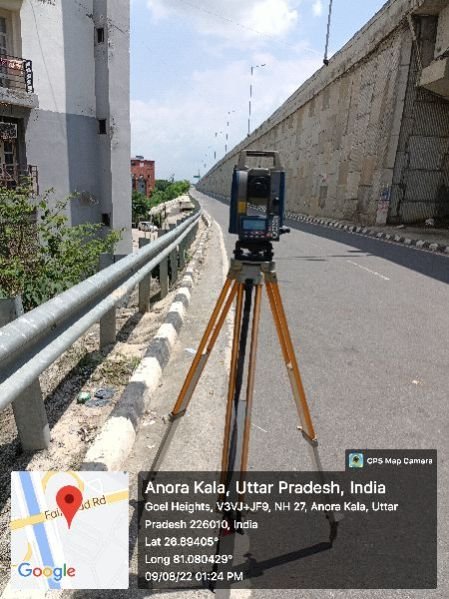
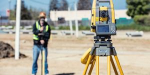
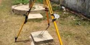
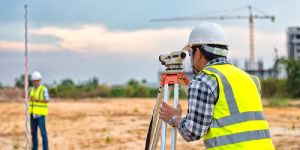
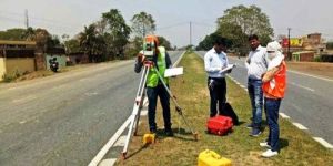
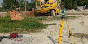
Established in the year 2016, we, Lucknow Land Surveyors, are one of the most reputed organizations engaged in proposing reliable and effective Construction and Engineering Survey Services and we also provide service for coordinate verification.  We are the registered agent for AAI height clearance. Our offered services are operative and are performed within the stated period with the help of expert & proficient professionals. To keep their reliability and efficiency, we apply the latest methodologies, equipment and higher quality accessories in rendering these services.


We are on the path of constant success and growth under the leadership of our mentor and guide, Mr Umesh Yadav \', our owner who holds huge experience in this field. His outstanding entrepreneurship and guiding skills have helped us in accomplishing our organizational goals.


The services offered by us are


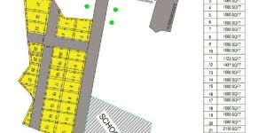
Land Surveying service


Canal surveying service


Topographic Survey Services


Building surveyor survey service


Electric line survey service


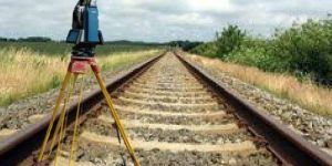
Railway track survey service


Soil testing service


And many more in this category


Our strength


With the support of the latest equipment’s and experienced professionals, we bring these services in a prompt, proficient and streamlined manner. Our offered services are under the client’s necessities and international standards of quality:


Why us?


Providing an extensive range of survey services


Excellent team of experts


Equipped with the latest technology


Experienced in many sectors

Read More »

Contact Information

Lucknow Land Surveyors

Find Popular IN Building Solution Service Providers

top